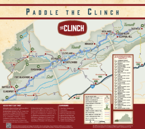
There are several existing access points along the Clinch River for canoes, kayaks and fishing. From the headwaters in Tazewell County to the Tennessee state line, you can spend days or hours exploring the Clinch. Please see the VA Dept. of Game and Inland Fisheries website about the Clinch for maps of each access point at this link.
1. Lavender/Critterville to McDonald’s Map
Put in at Richland’s new access point off Virginia Avenue. Take out behind the McDonald’s on Front Street.
2. McDonald’s to Blackford Bridge Map
Put in at the McDonald’s described above. Take out at Blackford Bridge access, located just upstream of Route 80.
3. Blackford Bridge to Puckett’s Hole Map
Distance: 7.3 miles
Gradient: 10.6 ft/mile
Put in at the Blackford Bridge Access described above. This float is excellent smallmouth bass fishing. Water may be challenging during high flows. The take out is located on the right side of the river at Puckett’s Hole landing off secondary route 652.
4. Puckett’s Hole to Nash’s Ford Map
Put in at Puckett’s Hole landing described above.. This float is a good continuation for smallmouth bass fishing. There are two falls located on this river stretch. The first falls is just downstream of the confluence with Cedar Creek, and the second is upstream of Hash’s Ford. Floaters should plan to portage at both locations. Take out on the left side of the river at Nash’s Ford landing on secondary route 645.
5. Nash’s Ford to Artrip Map
Gradient: 7.1 ft/mile
Put in at the Nash’s Ford access described above. Take out at Artrip Road off Route 661.
6. Artrip to Cleveland Map
Gradient: 7.1 ft/mile
Put in at the Artrip access described above. Take out on the right side of the river at the Cleveland access, located off of secondary route 600, and is adjacent to the baseball field.
7. Cleveland to Carterton Map
Distance: 7.5 miles
Gradient: 3.0 ft/mile
Put in at the Cleveland access point. This spot is ideal for flat water fishing. Aquatic life found along this route include bass, sunfish, walleye, musky, and catfish. Take out on the left side of the river at the Carterton access. Directions to Carterton Access: take route 614 off of route 640, then take a left onto route 855 and turn right across the railroad tracks and continue to the river.
8. Carterton to Old Castlewood Map
Gradient: 2.5 ft/mile
Put in at the Carterton access described above. This section is mostly flatwater, with various species for anglers. Take out at Old Castlewood, behind the baseball field on East Riverside Drive.
9. Old Castlewood to St Paul Map
Gradient: 2.5 ft/mile
Put in at the St Paul access described above. This section is mostly flatwater, with various species for anglers. Take out on the right, upstream of the town of St Paul.
10. St Paul to Burton’s Ford Map
Distance: 4.2 miles
Gradient: 1.6 ft/mile
Put in at the St Paul access described above on Riverside Drive. There are two ledges on this float. The first ledge is located just downstream of the railroad bridge in St Paul. Floaters should portage to the left. The second ledge is located further down the river, and should also be portaged to the left. This is another great spot for anglers of all types. Take out is on the left side at Burton’s Ford. Burton’s Ford directions: take route 65 south out of Castlewood, then bear right onto route 611 and follow to the river.
11. Burton’s Ford to Miller’s Yard Map
Distance: 7.1 miles
Gradient: 11.5 ft/mile
Put in at Burton’s Ford access described above and take out on the right side of the river at Miller’s Yard. This float contains ledges and falls that may require portaging, depending on the water level. Miller’s Yard directions: take secondary route 608 off of route 72. Follow route 608 under the railroad tracks and continue to the river. Takeout is just downstream of the swinging bridge.
12. Miller’s Yard to Dungannon Map
Distance: 3.7 miles
Gradient: 10 ft/mile
Put in at Miller’s Yard, described above. This is a shorter float for quick trips. This is a good float to catch bass and sunfish. Takeout is on the right, just downstream of the Route 65 bridge at Dungannon.
13. Dungannon to Route 659 Map
Distance: Variable
Gradient: 10 ft/mile
The Dungannon access has an smooth concreate boat launch. There are a variety of take-outs along route 659. Selection can be made based on distance and available access to the river for tailored routes. It is best to secure permission from the property owner when selecting a take-out.
14. Route 659 to Fort Blackmore Map
Distance: 8 miles*
Gradient: 3.1 ft/mile
Float distance is dependent on launch point selected on route 659. This is mainly a flatwater float. Bring an electric trolling motor to save on paddling. This float includes a 5-mile pool known to locals as “the retch”. Take out on the left, just downstream of the Route 72 bridge in Fort Blackmore.
15. Fort Blackmore to Slant Map
Distance: 7.9 miles
Gradient: 1.9 ft/mile
Put in at Fort Blackmore as described above. Pack your camera for this scenic float. This low gradient section is a slow float that lends itself to prime fishing, especially at Pendelton Island which is located just downstream from Fort Blackmore. Take out at either side of the hanging bridge off route 662.
16. Slant to Hill Station
Put in at the Slant access described above. Take out on the left side of the river, just upstream of the route 645 bridge. The Hill Station access is located off route 645 on the southeast side of the river.
17. Hill Station to Clinchport Map
Distance: 5.2 miles
Gradient: 2.0 ft/mile
Put in at the Hill Station access described above. This section is typical of the lower river with lazy pools for fishing. Take out on the right side of the river at the Clinchport access.
18. Clinchport to Speer’s Ferry Map
Distance: 2 miles
Gradient: 3.2 ft/mile
Put in at the Clinchport ramp. The first section of this float offers prime spots to catch bass and sunfish. Ledges in the lower section will offer walleye and sauger. Take out on the left side of the river at Speer’s Ferry near the railroad bridge off of route 627.
19. Speer’s Ferry to State Line Map
Distance: 9 miles
Gradient: 2.5 ft/mile
Put in at Speer’s Ferry described above. This route flows through beautiful views on the way to the Virginia-Tennessee border. Most of this float is through slow waters, so plan accordingly. Take out on the left side of the river at the State Line access off of route 627.
For more information, contact Heart of Appalachia at 276-762-0011. Clinch River Outdoor Recreation Guides and Maps are available at the Heart of Appalachia Visitor’s Center in St. Paul.